The world’s physical geography encompasses a wide range of features that shape the Earth’s surface and influence ecosystems, climate patterns, and human activities.
Some salient features include:

1. Continents and Oceans
The Earth’s surface is dominated by seven continents (Asia, Africa, North America, South America, Antarctica, Europe, and Australia) and five major oceans (Pacific, Atlantic, Indian, Southern, and Arctic).
Continents: Landmasses of Diversity
1. Asia: As the largest continent, Asia spans diverse climates and landscapes, from the frozen tundra of Siberia to the tropical rainforests of Southeast Asia. It hosts the world’s highest peak, Mount Everest, and is home to a significant portion of the global population.
2. Africa: Known for its vast deserts like the Sahara, Africa also boasts lush savannas, dense rainforests, and expansive mountain ranges such as the Atlas Mountains. It is rich in biodiversity, with numerous species found exclusively within its borders.
3. North America: This continent stretches from the Arctic tundra of Canada to the tropical rainforests of Central America. It includes diverse ecosystems such as the Great Plains, the Rocky Mountains, and the Everglades, along with major rivers like the Mississippi and the Columbia.
4. South America: South America is dominated by the Andes, the world’s longest mountain range, running along its western edge. It features the Amazon Rainforest, the world’s largest tropical rainforest, which supports unparalleled biodiversity.
5. Antarctica: The southernmost continent, Antarctica, is covered by a thick ice sheet and surrounded by the Southern Ocean. It is home to unique wildlife adapted to extreme cold, including penguins, seals, and various species of birds.
6. Europe: Known for its historical and cultural richness, Europe encompasses diverse landscapes from the Arctic Circle to the Mediterranean coast. It includes the Alps, the Carpathian Mountains, and the fertile plains of Eastern Europe.
7. Australia: A continent and a country, Australia is characterized by its vast deserts (e.g., the Outback), tropical rainforests in the north, and the Great Barrier Reef, the world’s largest coral reef system.
Oceans: The Blue Heart of the Earth
1. Pacific Ocean: The largest and deepest ocean, the Pacific covers more area than all landmasses combined. It is known for its Ring of Fire, a region of high volcanic and seismic activity.
2. Atlantic Ocean: The second-largest ocean, the Atlantic is crucial for global shipping and commerce. It separates the Americas from Europe and Africa and is known for its powerful ocean currents like the Gulf Stream.
3. Indian Ocean: The third-largest ocean, the Indian Ocean, connects Africa and Asia. It is home to diverse marine life and plays a significant role in the monsoon climate of South Asia.
4. Southern Ocean: Surrounding Antarctica, the Southern Ocean is characterized by strong westerly winds and cold waters. It supports unique ecosystems adapted to extreme cold conditions.
5. Arctic Ocean: The smallest and shallowest of the oceans, the Arctic Ocean is covered by sea ice for much of the year. It is home to polar bears, walruses, and other Arctic wildlife.
Interconnected Systems and Human Impact
Continents and oceans are interconnected through various processes such as ocean currents, atmospheric circulation, and the water cycle. They regulate global climate patterns, influence weather systems, and provide habitats for diverse flora and fauna.
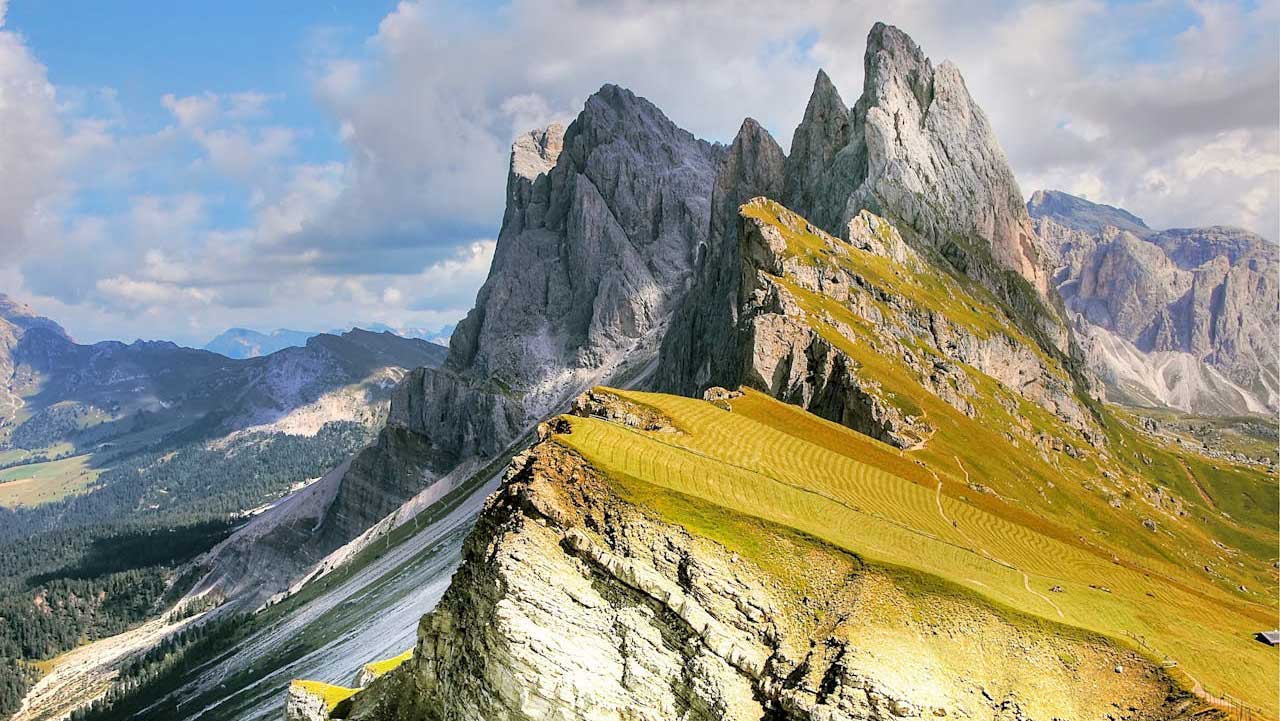
2. Mountains
Mountain ranges such as the Himalayas, Andes, Rockies, Alps, and others play significant roles in shaping climates, weather patterns, and human settlement patterns.
Mountains are broadly classified into several types based on their formation processes:
- Fold Mountains: These are formed when tectonic plates collide, causing the Earth’s crust to fold and uplift. The Himalayas, Andes, Alps, and Rockies are prime examples, with their jagged peaks and deep valleys.
- Fault-Block Mountains: These mountains are created when faults or cracks in the Earth’s crust force blocks of rock upwards. The Sierra Nevada in the United States and the Tetons in Wyoming are classic examples of fault-block mountains.
- Volcanic Mountains: Formed by volcanic activity, these mountains are built up over time by layers of lava and volcanic ash. Mount Fuji in Japan, Mount St. Helens in the United States, and Mount Kilimanjaro in Tanzania are well-known volcanic mountains.
- Dome Mountains: These mountains form when magma pushes up from below the Earth’s crust but doesn’t erupt, instead forming rounded domes of uplifted rock. The Black Hills in South Dakota, USA, are a notable example of dome mountains.
Features and Characteristics
1. Height and Peaks: Mountains are defined by their height above sea level. The tallest mountain in the world, Mount Everest (8,848 meters or 29,029 feet), is part of the Himalayan range, while other ranges like the Andes and the Alps boast numerous peaks exceeding 4,000 meters (13,123 feet).
2. Biodiversity: Mountains host a wide range of ecosystems due to their varying altitudes and climates. From alpine meadows and coniferous forests at lower elevations to barren rock and perpetual snow at higher elevations, mountains support diverse flora and fauna adapted to extreme conditions.
3. Water Sources: Mountains play a critical role in global hydrology as sources of major rivers and lakes. The Himalayas feed rivers like the Ganges, Yangtze, and Indus, while the Andes supply water to the Amazon Basin and the Rockies to the Colorado River.
4. Climate Influence: Mountains significantly influence local and regional climates. They create rain shadows, where moist air rises on one side, cools and releases precipitation, and then descends on the other side as dry air. This phenomenon affects rainfall patterns and agricultural productivity.
5. Geological Processes: Mountains are dynamic geological entities shaped by processes such as erosion, glaciation, and volcanic activity. Glaciers carve U-shaped valleys and cirques, while erosion exposes folded layers of rock that reveal Earth’s geological history.
Cultural Significance
Mountains hold profound cultural significance for many societies around the world. They have been revered as sacred places, sites of pilgrimage, and sources of inspiration in art, literature, and religion. For indigenous peoples, mountains often represent ancestral lands and spiritual connections to nature.
Conservation and Challenges
Mountains face significant environmental challenges, including climate change, deforestation, mining, and tourism impacts. Melting glaciers threaten freshwater supplies, while habitat fragmentation endangers endemic species. Conservation efforts are crucial to preserving mountain ecosystems and ensuring sustainable development for mountain communities.

3. Plate Tectonics
The Earth’s lithosphere is divided into tectonic plates that interact at plate boundaries, leading to processes like earthquakes, volcanic activity, and the formation of mountain ranges.
Key Concepts of Plate Tectonics
- Tectonic Plates: The Earth’s lithosphere is divided into several large and numerous smaller tectonic plates, ranging from major plates like the Pacific Plate to smaller ones like the Philippine Sea Plate. These plates are rigid segments of the Earth’s crust and upper mantle that float on the semi-fluid asthenosphere below.
- Plate Boundaries: The interactions between tectonic plates occur at plate boundaries, where geological activity is most intense. There are three main types of plate boundaries:
- Divergent Boundaries: Plates move away from each other, typically occurring along mid-ocean ridges where new oceanic crust is formed through volcanic activity. An example is the Mid-Atlantic Ridge.
- Convergent Boundaries: Plates move towards each other, leading to collisions and subduction (where one plate dives beneath another). These boundaries often result in mountain-building, volcanic activity, and earthquakes. The collision of the Indian Plate with the Eurasian Plate forms the Himalayas.
- Transform Boundaries: Plates slide past each other horizontally, causing faults and earthquakes. The San Andreas Fault in California is a well-known transform boundary.
- Subduction Zones: In convergent boundaries where oceanic plates collide with continental plates or other oceanic plates, the denser oceanic plate subducts beneath the less dense plate. This process generates deep ocean trenches and volcanic arcs, such as the Andes and the Cascades.
- Volcanism and Earthquakes: Plate tectonics explains the distribution of volcanoes and earthquakes worldwide. Volcanoes are often found at convergent and divergent boundaries where magma reaches the Earth’s surface. Earthquakes occur along all types of plate boundaries due to the movement and interaction of plates.
Geological Processes and Features
Plate tectonics governs various geological processes and features on Earth:
- Mountain Formation: The collision of tectonic plates at convergent boundaries leads to the uplift and formation of mountain ranges, such as the Himalayas and the Alps.
- Rift Valleys: Divergent boundaries can create rift valleys, such as the East African Rift System, where the Earth’s crust is being pulled apart.
- Mid-Ocean Ridges: Divergent boundaries in oceanic settings create underwater mountain ranges known as mid-ocean ridges, where new oceanic crust is continuously formed.
- Island Arcs: These form at convergent boundaries where oceanic plates subduct beneath another oceanic plate, creating chains of volcanic islands like Japan and Indonesia.
Historical Development and Significance
The theory of plate tectonics emerged in the mid-20th century, consolidating earlier ideas about continental drift proposed by Alfred Wegener in the early 20th century. It has since become the cornerstone of modern geology, explaining not only the distribution of geological phenomena but also providing insights into Earth’s history, climate evolution, and the distribution of resources.
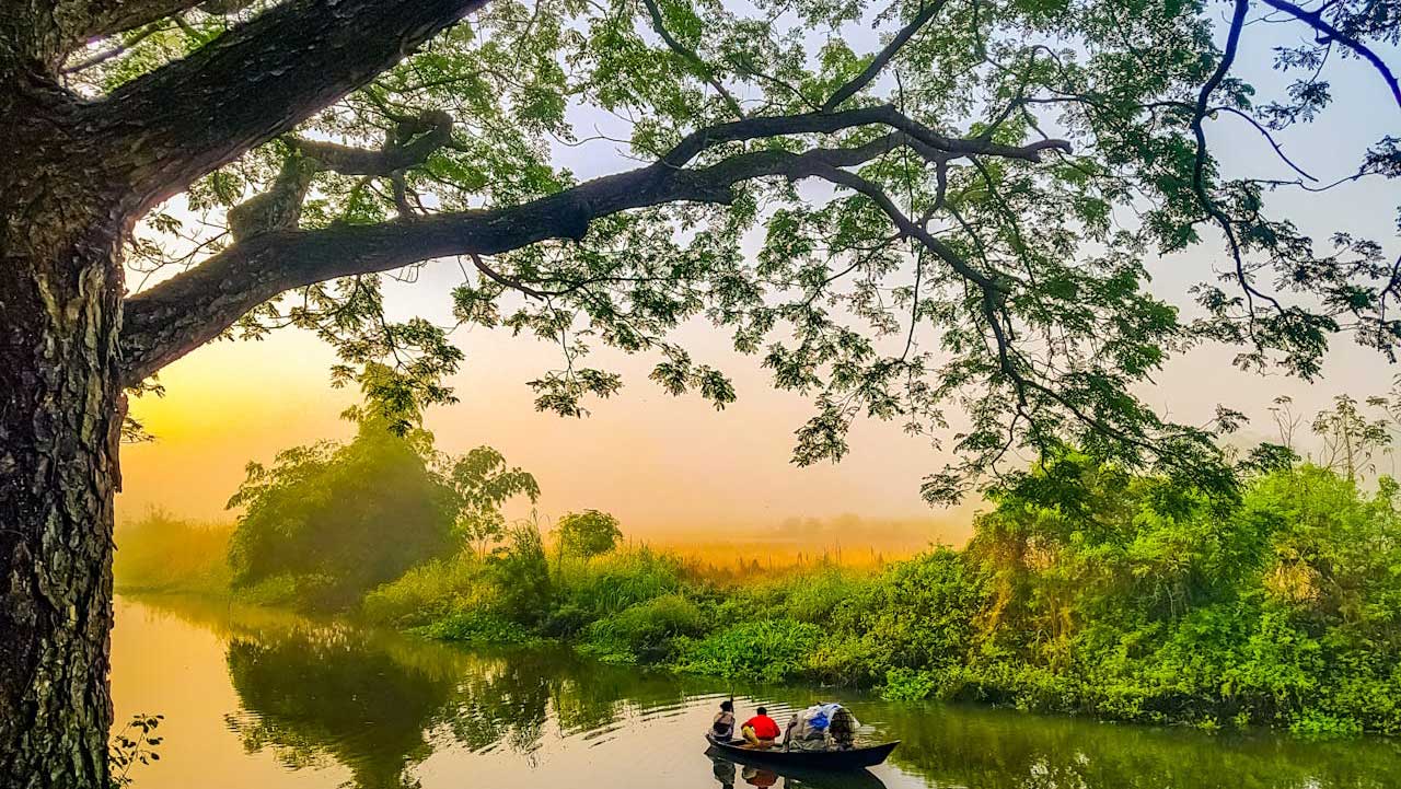
4. Rivers and Lakes
Rivers and lakes are vital components of Earth’s hydrological cycle, shaping landscapes, supporting ecosystems, and sustaining human societies around the world. Major rivers like the Amazon, Nile, Yangtze, and others, along with large freshwater lakes such as the Great Lakes of North America and Lake Baikal in Siberia, influence regional climates, ecosystems, and human settlement patterns.
Rivers: Channels of Dynamic Flow
1. Hydrological Cycle Contribution: Rivers are essential in the hydrological cycle, transporting water from land to oceans through evaporation, precipitation, and runoff. They act as drainage basins for vast regions, collecting rainwater and melting snow from mountains and plains.
2. Classification and Characteristics:
- Major World Rivers: Rivers like the Amazon (South America), Nile (Africa), Yangtze (Asia), and Mississippi (North America) are among the longest and most voluminous rivers globally. They traverse continents, shaping landscapes and providing crucial water resources.
- River Systems: Rivers form interconnected networks known as river systems or watersheds. These systems include tributaries that feed into main rivers, creating intricate patterns of flow across landscapes.
- Erosional and Depositional Processes: Rivers erode rocks and sediment, forming valleys and canyons over millennia. They deposit sediment in floodplains and deltas, enriching soils and supporting agriculture.
3. Ecological Importance:
- Biodiversity Hotspots: Rivers support diverse ecosystems, from freshwater fish and amphibians to riparian forests and wetlands. They provide habitats for numerous species and serve as migration routes for wildlife.
- Economic Utilization: Rivers are essential for agriculture, industry, transportation, and recreation. They supply water for irrigation, generate hydroelectric power, facilitate shipping and trade, and offer recreational activities like fishing and boating.
4. Human Impacts and Management:
- Environmental Challenges: Human activities such as dam construction, pollution, deforestation, and over-extraction of water pose significant threats to river ecosystems. These impacts degrade water quality, disrupt habitats, and reduce biodiversity.
- Conservation Efforts: Conservation initiatives aim to restore and protect river ecosystems. Efforts include habitat restoration, pollution control measures, sustainable water management practices, and the establishment of protected areas.
Lakes: Reservoirs of Freshwater Diversity
1. Formation and Types:
- Glacial Lakes: Formed by glaciers carving out depressions in landscapes, such as the Great Lakes in North America and Lake Geneva in Europe.
- Tectonic Lakes: Created in fault zones or tectonic depressions, like Lake Baikal in Russia and Lake Tanganyika in Africa.
- Volcanic Lakes: Resulting from volcanic activity, such as Crater Lake in the United States and Lake Taupo in New Zealand.
2. Ecological Significance:
- Biodiversity: Lakes support diverse aquatic life, including fish, mollusks, and plankton. They are crucial habitats for endemic species and migratory birds.
- Water Supply: Lakes store freshwater, providing drinking water, irrigation, and industrial needs for surrounding communities. They regulate local climates and contribute to groundwater recharge.
3. Human Uses and Conservation:
- Recreation and Tourism: Lakes attract tourists for activities like boating, swimming, and camping. They also support local economies through tourism and recreational services.
- Environmental Threats: Similar to rivers, lakes face threats from pollution, invasive species, habitat loss, and climate change. Eutrophication, caused by nutrient runoff, is a common issue affecting lake ecosystems.
- Management Strategies: Lake conservation efforts focus on reducing pollution, controlling invasive species, promoting sustainable fishing practices, and establishing protected areas to preserve biodiversity.

5. Deserts
Deserts are vast, arid regions characterized by low precipitation levels, sparse vegetation, and extreme temperature fluctuations. Despite their harsh conditions, deserts support unique ecosystems, offer insights into Earth’s climatic history, and present challenges and opportunities for human habitation and exploration. Deserts like the Sahara, Gobi, Arabian, and others cover significant portions of the Earth’s surface, influencing global climate patterns and presenting challenges for human habitation.
Types of Deserts
Deserts are classified based on their geographical location, climate, and formation processes:
- Subtropical Deserts: Found along the Tropic of Cancer and the Tropic of Capricorn, these deserts experience hot temperatures during the day and cooler nights. Examples include the Sahara Desert in Africa, the Arabian Desert in the Middle East, and the Sonoran Desert in North America.
- Cold Deserts: Located at higher latitudes or altitudes, these deserts experience cold winters with snowfall. Examples include the Gobi Desert in Asia and the Great Basin Desert in the United States.
- Coastal Deserts: These deserts occur along the western edges of continents where cold ocean currents inhibit precipitation. The Atacama Desert in Chile and the Namib Desert in Namibia are prominent coastal deserts.
- Rain Shadow Deserts: Formed on the leeward side of mountain ranges, these deserts receive little precipitation due to the blocking of moisture-laden winds. Examples include the Mojave Desert in the United States and the Patagonian Desert in Argentina.
Features and Characteristics
- Climate: Deserts are characterized by low annual precipitation (often less than 250 mm or 10 inches) and high evaporation rates. They exhibit wide temperature ranges, with scorching daytime highs and cold nighttime lows due to minimal cloud cover.
- Landforms: Deserts showcase a variety of landforms shaped by erosion and deposition processes. These include sand dunes (such as in the Sahara and the Arabian Desert), rocky plateaus (like in the Atacama Desert), and salt flats (such as the Bonneville Salt Flats in the United States).
- Vegetation and Adaptations: Plant life in deserts has adapted to conserve water and withstand extreme temperatures. Examples include succulents like cacti, drought-resistant shrubs, and ephemeral plants that bloom quickly after rare rains.
- Wildlife: Desert ecosystems support a surprising diversity of wildlife adapted to arid conditions. Species include camels and desert foxes (adapted to extreme temperatures), reptiles like rattlesnakes and lizards, and birds such as the roadrunner and desert owl.
Human Interaction and Challenges
- Historical and Cultural Significance: Deserts have played crucial roles in human history and culture. They have been traversed by ancient trade routes (like the Silk Road), inhabited by indigenous peoples (such as the Bedouins in the Sahara), and served as settings for spiritual retreats and quests.
- Resource Extraction: Deserts are rich in mineral resources such as oil, gas, and minerals. Extractive industries pose challenges to desert ecosystems through habitat disruption, pollution, and depletion of water resources.
- Water Scarcity: Water is a scarce and precious resource in deserts, crucial for human settlements, agriculture, and industrial activities. Sustainable water management practices are essential to mitigate the impact of water scarcity in these regions.
- Climate Change: Desert regions are vulnerable to climate change impacts, including increased temperatures, altered precipitation patterns, and desertification (the spread of desert-like conditions into semi-arid areas). These changes threaten both natural ecosystems and human livelihoods.
Conservation and Future Outlook
Conservation efforts in deserts focus on protecting biodiversity, managing water resources sustainably, promoting renewable energy projects (like solar farms), and implementing policies to mitigate climate change impacts. Balancing human development with ecological preservation is crucial for ensuring the long-term health and resilience of desert ecosystems.

6. Climate Zones
Earth’s climate zones are defined by distinct weather patterns, temperature ranges, and ecological characteristics influenced by latitude, elevation, proximity to oceans, and prevailing wind patterns. These zones play a crucial role in shaping global biodiversity, agriculture, and human habitation patterns. Different climate zones, including tropical, temperate, arid, polar, and highland climates, are determined by factors like latitude, altitude, proximity to oceans, and prevailing wind patterns.
Classification of Climate Zones
Climate zones are typically categorized based on temperature and precipitation patterns:
- Tropical Zone (Tropics):
- Characteristics: Located near the equator between the Tropic of Cancer and the Tropic of Capricorn, the tropical zone experiences high temperatures year-round and abundant rainfall.
- Ecological Features: Home to tropical rainforests, lush vegetation, and diverse wildlife. Examples include the Amazon Rainforest in South America and the Congo Basin in Africa.
- Subtropical Zone:
- Characteristics: Located between the tropical and temperate zones, these regions experience warm to hot temperatures and variable precipitation patterns.
- Ecological Features: Vegetation includes savannas (grasslands with scattered trees), Mediterranean shrublands, and semi-arid deserts. Examples include the Mediterranean Basin, parts of Australia, and the southern United States.
- Temperate Zones (Temperate Belt):
- Characteristics: Found between approximately 30° and 60° latitude in both hemispheres, temperate zones experience moderate temperatures with distinct seasonal variations.
- Ecological Features: Support a mix of deciduous and coniferous forests, grasslands, and agricultural areas. Examples include the eastern United States, Europe, and parts of China.
- Boreal Zone (Taiga):
- Characteristics: Located in the high latitudes of the Northern Hemisphere, typically between 50° and 70° N latitude, the boreal zone experiences long, cold winters and short, cool summers.
- Ecological Features: Dominated by coniferous forests (taiga), characterized by evergreen trees like spruce, fir, and pine. Examples include Siberia in Russia, Canada, and Scandinavia.
- Polar Zones:
- Characteristics: Found near the North and South Poles, these zones experience extremely cold temperatures year-round with minimal sunlight during winter months.
- Ecological Features: Sparse vegetation such as mosses, lichens, and tundra shrubs. In the Antarctic, the landscape is dominated by ice and snow.
- Subdivisions: Arctic tundra in the Northern Hemisphere and Antarctic tundra in the Southern Hemisphere.
Factors Influencing Climate Zones
- Latitude: Distance from the equator affects the angle and intensity of sunlight, influencing temperature variations across different climate zones.
- Elevation: Higher elevations generally have cooler temperatures due to lower atmospheric pressure and decreased air density.
- Ocean Currents: Warm ocean currents can moderate temperatures along coastal regions, influencing climate patterns in adjacent land areas.
- Topography: Mountain ranges create rain shadows, affecting precipitation patterns and creating microclimates.
- Wind Patterns: Prevailing wind directions influence moisture transport and precipitation distribution, contributing to regional climate characteristics.
Human Impacts and Adaptation
Human activities such as deforestation, urbanization, and greenhouse gas emissions contribute to climate change, affecting global climate patterns and exacerbating extreme weather events. Adaptation strategies include sustainable agriculture, water management practices, and mitigation efforts to reduce carbon emissions.

7. Ecosystem Diversity
Ecosystem diversity refers to the variety of ecosystems present on Earth, encompassing a wide range of habitats, species, and ecological processes. From lush tropical rainforests to icy polar regions, each ecosystem plays a unique role in sustaining life, regulating climate, and providing essential ecosystem services. From tropical rainforests to tundra, the world’s physical geography supports a vast array of ecosystems, each with unique flora and fauna adapted to local conditions.
Major Types of Ecosystems
- Tropical Rainforests:
- Location: Found near the equator in regions with high rainfall and consistently warm temperatures.
- Characteristics: Known for their dense vegetation, diverse tree species, and abundant wildlife. Tropical rainforests harbor a wealth of biodiversity, including countless plant species, insects, mammals, birds, and amphibians.
- Examples: The Amazon Rainforest in South America, the Congo Basin in Africa, and the rainforests of Southeast Asia.
- Temperate Deciduous Forests:
- Location: Located in regions with moderate temperatures and distinct seasonal changes.
- Characteristics: Dominated by broad-leaved deciduous trees that shed their leaves in the fall. These forests support a variety of wildlife, including deer, squirrels, birds, and insects.
- Examples: Eastern deciduous forests of North America, forests in Europe, and parts of East Asia.
- Deserts:
- Location: Found in arid regions with low precipitation and extreme temperature variations.
- Characteristics: Vegetation is sparse and adapted to conserve water, including cacti, succulents, and drought-resistant shrubs. Desert ecosystems support specialized animals like camels, lizards, snakes, and insects.
- Examples: Sahara Desert in Africa, Arabian Desert in the Middle East, and the Atacama Desert in South America.
- Grasslands:
- Location: Found in both temperate and tropical regions with moderate rainfall.
- Characteristics: Dominated by grasses and herbaceous plants rather than trees. Grasslands support large herds of grazing animals such as bison, zebras, antelope, and kangaroos.
- Examples: North American prairies, African savannas, and the pampas of South America.
- Tundra:
- Location: Found in high-latitude regions near the Arctic and Antarctic circles.
- Characteristics: Characterized by low temperatures, permafrost (permanently frozen ground), and short growing seasons. Tundra vegetation includes mosses, lichens, dwarf shrubs, and hardy grasses. Animals like caribou, Arctic foxes, and polar bears are adapted to these harsh conditions.
- Examples: Arctic tundra in the Northern Hemisphere and Antarctic tundra in the Southern Hemisphere.
- Aquatic Ecosystems:
- Marine Ecosystems: Found in oceans and seas, ranging from coastal zones to the open ocean. Marine ecosystems include coral reefs, kelp forests, deep-sea hydrothermal vents, and estuaries.
- Freshwater Ecosystems: Found in lakes, rivers, ponds, and wetlands. These ecosystems support diverse aquatic life, including fish, amphibians, waterfowl, and aquatic plants.
Importance of Ecosystem Diversity
- Biodiversity: Ecosystem diversity supports a vast array of plant and animal species, contributing to genetic diversity and ecological resilience. It enhances ecosystem productivity and stability, benefiting human well-being through ecosystem services like pollination, water purification, and climate regulation.
- Climate Regulation: Different ecosystems play crucial roles in regulating local and global climate patterns. Forests sequester carbon dioxide, wetlands mitigate floods, and oceans influence weather patterns through heat absorption and circulation.
- Cultural and Aesthetic Value: Ecosystem diversity enriches human cultures and traditions, providing inspiration for art, literature, and spiritual beliefs. It offers recreational opportunities for eco-tourism and outdoor activities, fostering connections between people and nature.
Threats to Ecosystem Diversity
- Habitat Destruction: Deforestation, urbanization, and land conversion for agriculture threaten ecosystems worldwide, leading to habitat loss and fragmentation.
- Climate Change: Global warming affects ecosystems by altering temperature regimes, precipitation patterns, and species distributions. It exacerbates threats to vulnerable species and habitats.
- Pollution and Overexploitation: Pollution from industrial activities, chemical runoff, and overfishing disrupts ecosystem health and diminishes biodiversity.
Conservation Efforts and Sustainability
Conservation efforts aim to protect and restore ecosystem diversity through initiatives such as establishing protected areas, implementing sustainable land management practices, promoting biodiversity conservation, and addressing climate change impacts. Sustainable development strategies seek to balance human needs with ecological preservation, ensuring that future generations can benefit from Earth’s diverse and resilient ecosystems.

8. Coastlines
Coastlines are dynamic interfaces where land and sea converge, shaping diverse ecosystems, supporting human livelihoods, and presenting unique geological and ecological features. They are influenced by natural processes like erosion and deposition, as well as human activities that impact their health and sustainability. Coastal features such as cliffs, beaches, estuaries, and coral reefs are critical habitats and are vulnerable to environmental changes and human activities.
Characteristics of Coastlines
- Physical Features:
- Beaches: Sandy or pebbly shores formed by wave action and coastal currents. Beaches vary in size and composition, attracting tourists and supporting recreational activities.
- Cliffs and Bluffs: Steep rock formations carved by erosion along coastlines, often revealing geological layers and fossils.
- Coves and Bays: Sheltered inlets formed by erosion or tectonic activity, providing habitats for marine life and safe harbors for ships.
- Estuaries: Coastal areas where rivers meet the sea, characterized by brackish water (mix of fresh and saltwater) and rich biodiversity. Estuaries serve as nurseries for fish and support migratory bird populations.
- Ecological Diversity:
- Marine Habitats: Coastlines host diverse marine ecosystems including coral reefs, seagrass beds, and kelp forests. These habitats support a variety of fish, invertebrates, and marine mammals.
- Intertidal Zones: Areas between high and low tide levels where organisms like barnacles, crabs, and anemones thrive. Intertidal zones experience fluctuations in temperature, salinity, and exposure to waves.
- Mangrove Forests: Found in tropical and subtropical coastlines, mangroves are salt-tolerant trees and shrubs that stabilize shorelines, provide nurseries for fish, and filter pollutants.
- Geological Processes:
- Erosion and Deposition: Coastal erosion by waves and currents reshapes coastlines over time, forming sea cliffs, sea stacks, and beaches. Sediment deposition creates barrier islands, deltas, and coastal plains.
- Coastal Landforms: Features like sea caves, arches, and stacks are sculpted by wave erosion, illustrating the ongoing interaction between land and sea.
Human Interaction and Uses
- Economic Importance:
- Shipping and Transportation: Coastlines facilitate maritime trade, shipping routes, and ports that support global commerce and transportation.
- Tourism and Recreation: Coastal tourism attracts millions of visitors annually for beach activities, water sports, and wildlife watching. Coastal resorts and hotels contribute to local economies.
- Resource Extraction:
- Fishing and Aquaculture: Coastal waters support commercial and subsistence fishing operations, harvesting seafood like fish, shellfish, and crustaceans. Aquaculture farms cultivate fish and shellfish in coastal waters.
- Minerals and Energy: Offshore oil and gas extraction, as well as mining of sand and gravel, occur in coastal regions, impacting marine habitats and ecosystems.
- Environmental Challenges:
- Coastal Development: Urbanization and infrastructure projects near coastlines can lead to habitat loss, pollution from runoff, and increased vulnerability to coastal erosion and storms.
- Climate Change: Rising sea levels, more frequent storms, and ocean acidification threaten coastal communities and ecosystems. Coastal erosion and inundation exacerbate risks for low-lying coastal areas.
Conservation and Management
- Marine Protected Areas (MPAs): Establishing MPAs helps conserve biodiversity, protect critical habitats, and manage human activities in coastal waters.
- Coastal Zone Management: Integrated coastal zone management (ICZM) plans aim to balance conservation with sustainable development, addressing land use, pollution control, and disaster preparedness.
- Restoration and Rehabilitation: Efforts focus on restoring degraded coastal habitats, such as mangrove reforestation and beach nourishment projects to combat erosion.
Future Perspectives
Coastlines face complex challenges from human activities and environmental changes. Sustainable coastal management, conservation of marine biodiversity, and adaptation to climate impacts are essential for safeguarding these valuable ecosystems and ensuring their resilience for future generations. Understanding the interconnectedness of land and sea dynamics is crucial for maintaining the ecological health and socio-economic vitality of coastlines worldwide.

9. Natural Hazards
Natural hazards are natural phenomena or processes that pose risks to human life, property, and the environment. They result from geological, meteorological, hydrological, and biological processes, often occurring without human influence. Understanding these hazards is crucial for disaster preparedness, mitigation efforts, and building resilience in vulnerable regions. Physical geography includes natural hazards like hurricanes, tsunamis, floods, droughts, and wildfires, which can have significant impacts on societies and environments.
Types of Natural Hazards
- Geological Hazards:
- Earthquakes: Sudden shaking of the Earth’s crust due to tectonic movements along faults. Earthquakes can cause ground rupture, tsunamis (large sea waves), landslides, and structural damage.
- Volcanic Eruptions: Release of molten rock (magma), ash, and gases from volcanic vents. Eruptions can trigger pyroclastic flows, ashfall, lava flows, and lahars (mudflows).
- Landslides: Rapid movement of rock, soil, and debris down a slope, often triggered by heavy rainfall, earthquakes, or volcanic activity. Landslides can bury infrastructure and communities.
- Meteorological Hazards:
- Tropical Cyclones (Hurricanes, Typhoons): Intense storms with strong winds and heavy rainfall, forming over warm ocean waters. Cyclones can cause storm surges, flooding, and widespread destruction.
- Tornadoes: Violently rotating columns of air extending from thunderstorms to the ground. Tornadoes can cause severe damage to buildings, vehicles, and infrastructure within minutes.
- Thunderstorms: Atmospheric disturbances with lightning, thunder, strong winds, and heavy rain. Severe thunderstorms can produce hail, flash floods, and tornadoes.
- Hydrological Hazards:
- Floods: Overflow of water onto normally dry land, often due to heavy rainfall, snowmelt, or dam failures. Floods can cause extensive damage to homes, crops, and infrastructure.
- Tsunamis: Large ocean waves generated by underwater earthquakes, volcanic eruptions, or landslides. Tsunamis can inundate coastal areas with destructive force.
- Droughts: Prolonged periods of low precipitation leading to water shortages, crop failures, and ecological stress. Droughts impact agriculture, water supply, and ecosystems.
- Biological Hazards:
- Epidemics and Pandemics: Outbreaks of infectious diseases that spread rapidly among populations. Examples include influenza pandemics and recent outbreaks like COVID-19.
- Insect Infestations: Population explosions of insects like locusts or bark beetles, damaging crops, forests, and ecosystems.
- Wildfires: Uncontrolled fires in forests, grasslands, or urban areas, often exacerbated by dry conditions, heatwaves, or human activities. Wildfires can destroy homes and habitats.
Impact and Vulnerability
Natural hazards impact communities differently based on factors such as location, population density, infrastructure resilience, and socio-economic conditions. Vulnerable populations often suffer disproportionately from disasters, facing challenges in evacuation, access to emergency services, and recovery efforts.
Mitigation and Preparedness
- Early Warning Systems: Monitoring and alert systems for earthquakes, tsunamis, cyclones, and other hazards provide crucial time for evacuation and preparation.
- Building Codes and Infrastructure: Designing resilient infrastructure, enforcing building codes, and retrofitting vulnerable structures reduce damage from earthquakes, hurricanes, and floods.
- Community Preparedness: Education, training, and drills enhance public awareness and readiness for natural disasters. Community-based organizations play vital roles in disaster response and recovery.
Global Perspectives and Collaboration
Natural hazards are global challenges requiring international cooperation in monitoring, research, and disaster management strategies. Organizations like the United Nations, World Meteorological Organization (WMO), and International Red Cross coordinate efforts to improve resilience and mitigate risks worldwide.

10. Human Impact
Human activities have significantly impacted the world’s physical geography, altering landscapes, ecosystems, and natural processes on a global scale. These impacts, driven by population growth, industrialization, urbanization, and resource extraction, have profound consequences for the environment, biodiversity, and climate systems. Human activities such as urbanization, deforestation, agriculture, and industrialization interact with the physical environment, often causing environmental degradation and changes in natural landscapes.
Human Impact on Physical Geography
1. Deforestation and Land Use Change
- Clearing of Forests: Deforestation for agriculture, logging, and urban expansion has led to the loss of primary forests and biodiversity hotspots, disrupting ecosystems and carbon storage.
- Land Conversion: Conversion of natural habitats into agricultural land, urban areas, and infrastructure alters hydrological cycles, increases soil erosion, and reduces natural habitat for wildlife.
2. Climate Change
- Greenhouse Gas Emissions: Burning fossil fuels for energy, industrial processes, and transportation releases carbon dioxide (CO2) and other greenhouse gases, contributing to global warming.
- Impacts on Physical Geography: Climate change intensifies weather patterns, accelerates melting of polar ice caps and glaciers, raises sea levels, and shifts precipitation patterns, affecting ecosystems and coastal areas.
3. Water Resources and Aquatic Systems
- Water Withdrawal: Dams, irrigation projects, and water extraction for agriculture and urban consumption alter river flows, impacting downstream ecosystems and reducing freshwater availability.
- Pollution: Industrial discharge, agricultural runoff, and urban waste contaminate water bodies, leading to eutrophication, loss of biodiversity, and threats to human health.
4. Urbanization and Infrastructure Development
- Urban Expansion: Rapid urban growth leads to land degradation, loss of green spaces, and increased heat island effects, altering local climates and biodiversity.
- Infrastructure Impact: Construction of roads, dams, and mining operations disrupts natural habitats, fragments ecosystems, and contributes to soil erosion and sedimentation in rivers.
5. Coastal and Marine Environments
- Coastal Development: Urbanization, tourism, and infrastructure along coastlines contribute to habitat destruction, coastal erosion, and loss of mangroves and coral reefs.
- Overfishing and Pollution: Unsustainable fishing practices, marine pollution (e.g., plastics), and oil spills degrade marine ecosystems, threatening biodiversity and fisheries.
6. Mining and Resource Extraction
- Surface Mining: Open-pit mining and extraction of minerals, oil, and gas alter landscapes, cause habitat destruction, and release toxic substances into soil and water.
- Deforestation: Logging and clearing forests for timber and mining operations disrupt ecosystems, reduce biodiversity, and increase soil erosion and sedimentation in rivers.
7. Air and Soil Pollution
- Industrial Emissions: Release of pollutants such as sulfur dioxide (SO2), nitrogen oxides (NOx), and particulate matter contributes to air pollution, acid rain, and respiratory diseases.
- Soil Degradation: Intensive agriculture, deforestation, and improper land management practices lead to soil erosion, desertification, and loss of fertile land for agriculture.
Mitigation and Conservation Efforts
Addressing the human impact on physical geography requires concerted efforts in conservation, sustainable resource management, and climate action:
- Conservation Initiatives: Establishing protected areas, national parks, and marine reserves to preserve biodiversity and restore degraded ecosystems.
- Sustainable Development: Adopting sustainable practices in agriculture, forestry, fisheries, and urban planning to minimize environmental impacts and promote resilience.
- Climate Mitigation: Reducing greenhouse gas emissions through renewable energy adoption, energy efficiency measures, and international agreements like the Paris Agreement.
- Environmental Policy: Enforcing regulations, implementing environmental impact assessments, and promoting green technologies to mitigate negative impacts on physical geography.